
hotel & travel information
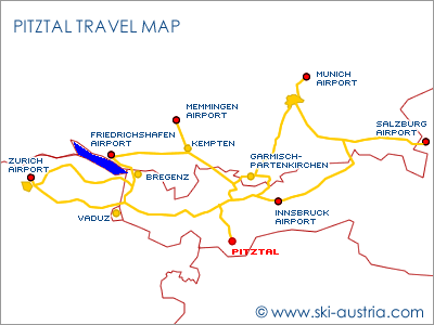
Distance to Innsbruck Airport:
90km
Distance to Memmingen Airport: 177km
Distance to Friedrichshafen Airport: 201km
Distance to Munich Airport: 231km
Nearest railway station to Pitztal: Imst - 39km
getting to the pitztal by air
Innsbruck airport has by far the shortest transfer time to the Pitz valley, but Munich is not a bad option and Salzburg airport is also easily accessible through the motorway network.
 Innsbruck
Airport
Innsbruck
Airport
The end of the Pitztal is around ninety minutes' drive from Innsbruck airport. The route along the Inn valley motorway heads due west through to the junction at Imst and then up into the valley via the towns of Arzl, Wenns and Jerzens before the long haul through to the hamlets closer to the ski areas. The road is a small valley road which can sometimes become crowded in high season.
Innsbruck has a wide selection of charter flights which mainly arrive on the weekend, as well as a good choice of scheduled flights including some of the low-cost carriers to the UK and Vienna.
Memmingen
Airport
Allgäu Airport, the proper name for the airport at Memmingen, acts as an alternative 'Munich Airport' for low-cost carriers and those aiming for destinations to the west of the Bavarian capital. It is not a bad solution for the Pitztal with motorway much of the way down towards the Austrian border near Reutte and then country roads (and the Fern Pass) through to the Inn valley motorway.
Friedrichshafen
Airport
Friedrichshafen Airport has been a popular option for visitors wanting to head for the west of Austria for some years now, even if it has been overtaken by Memmingen. The route from the airport follows the northern shore of Lake Constance and then crosses onto the Austrian motorway system at Bregenz before following the road all the way through the Arlberg to Imst.
Munich
Airport
Munich Airport is located around three hours away from the Pitztal. The airport is situated to the north of the city, and there are various options for travelling into Austria. The first - and longest but perhaps easiest - is to use the motorway network which bypasses Munich to the east and then heads down to Rosenheim, where it joins up with the motorway from Salzburg, and the border at Kufstein.
Otherwise drivers can head south through Munich towards Austria. At Garmisch-Partenkirchen there is another choice: either head towards Seefeld and then to Imst via Telfs, or take the Ehrwald direction over the Fernpass to Imst.
train travel
 Imst
Railway Station
Imst
Railway Station
Imst-Pitztal railway station in the Inn valley is the closest to to the Pitztal and is on the direct line from Innsbruck, Salzburg and Munich. Buses run during the day through to early evening hourly from the railway station on the sixty-minute journey, and taxis are also available.
finding your way around the resort
Hotels are dotted all along the Pitztal, with concentrations of them at the far end near the main ski areas and in the larger communities such as St Leonhard im Pitztal.
But even those hotels in the quiet hamlets along the road have excellent road access to the skiing - either by personal car or with the frequent ski buses.
The maps below display many of the four- and three-star hotels in the Pitz valley. As the valley is so long there are two maps displayed - one for the lower valley and the Hochzeiger ski area and one for the upper valley and the glacier and Rifflsee area. Even so the maps are set initially at quite a low resolution but you can zoom the map in and out by using the controls and switch between satellite and traditional map views.
The hotels listed below are all have an official rating of four or three stars. Those who are looking for something a little more homely or a different type of accommodation might like to use the search box here, which checks availability for all of the resort.
Booking.comhotels in arzl
Arzl is the hamlet at the entrance to the Pitz valley - most convenient to get to but furthest away from any of the ski areas.
Ostersteinstrasse 15
A-6471 Arzl im Pitztal
Tel: 05412 69000
Fax: 05412 6900100
Website: www.arzlerhof.at
Grube 2
A-6471 Arzl im Pitztal
Tel: 05412 63141
Fax: 05412 65910
Website: www.skigebiet.at
Wald Mairhof 41
A-6471 Arzl im Pitztal
Tel: 05412 64136
Fax: 05412 65560
Website: www.ferienhotel-bergland.at
hotels in wenns
Wenns is the second major settlement in the Pitz valley and is close to the Hochzeiger ski area.
Oberdorf 211
A-6473 Wenns im Pitztal
Tel: 05414 87426
Fax: 05414 86344
Website: www.ferienhotels-tirol.at
Oberdorf 215
A-6473 Wenns im Pitztal
Tel: 05414 87220
Fax: 05414 86430
Website: www.pitztalerhof.at
St. Margarethen 643
A-6473 Wenns im Pitztal
Tel: 05414 87215
Fax: 05414 8721515
Website: www.sailer-und-stefan.at
Unterdorf 52
A-6473 Wenns im Pitztal
Tel: 05414 87215
Fax: 05414 8721515
Website: www.sailer-und-stefan.at
hotels in jerzens
Jerzens is the main resort town of the lower Pitz valley and is located at the base of the Hochzeiger ski area.
Liss 300
A-6474 Jerzens
Tel: 05414 86086
Fax: 05414 8608640
Website: www.alpenroyal.at
Kaitanger 173
A-6474 Jerzens
Tel: 05414 87352
Fax:
Website: www.panorama-alpin.at
Oberfeld 170
A-6474 Jerzens
Tel: 05414 8510
Fax: 05414 851012
Website: www.jerznerhof.at
Liss 182
A-6474 Jerzens
Tel: 05414 85500
Fax: 05414 855060
Website: www.venetblick.com
Oberfeld 159
A-6474 Jerzens
Tel: 05414 8500
Fax: 05414 850055
Website: www.ferienhotels-tirol.at
Liss 257
A-6474 Jerzens
Tel: 05414 86303
Fax: 05414 863036
Website: www.hotel-romantica.at
accommodation map for wenns and jerzens
A map of the lower Pitz valley with some of the accommodation options.
Enter your proposed dates for winter accommodation availability. (The default view is for the following day so there may be limited accommodation available outside the main tourism seasons!)
Zoom in for more choice and click on the prices for more details:
hotels in st leonhard
The community of St Leonhard im Pitztal covers the village of the same name in the upper Pitz valley and the smaller hamlets all the way through to Mandarfen and the access to the Pitztal glacier.
Mandarfen 23
A-6481 St Leonhard im Pitztal
Tel: 05413 86214
Fax: 05413 8621420
Website: pitztal.at
Mittelberg 48
A-6481 St Leonhard im Pitztal
Tel: 05413 86292
Fax: 05413 8629254
Website: www.gletscherblick.at
Plangeross 10
A-6481 St Leonhard im Pitztal
Tel: 05413 86215
Fax: 05413 862155
Website: www.kirchenwirt-pitztal.at
Mandarfen 81
A-6481 St Leonhard im Pitztal
Tel: 05413 86271
Fax: 05413 86272
Website: www.mandarfnerhof.at
Mandarfen 86
A-6481 St Leonhard im Pitztal
Tel: 05413 86386
Fax: 05413 8638633
Website: www.mittagskogel.at
Weisswald 41
A-6481 St Leonhard im Pitztal
Tel: 05413 86220
Fax: 05413 86352
Website: www.hotel-seppl.com
Plangeross 36
A-6481 St Leonhard im Pitztal
Tel: 05413 86203
Fax: 05413 8620352
Website: www.sportalm.net
Tieflehn 20
A-6481 St Leonhard im Pitztal
Tel: 05413 86209
Fax: 05413 8620951
Website: www.tieflehnerhof.at
Mandarfen 73
A-6481 St Leonhard im Pitztal
Tel: 05413 86361
Fax: 05413 863615
Website: www.hotel-vier-jahreszeiten.at
Mandarfen 46
A-6481 St Leonhard im Pitztal
Tel: 05413 86207
Fax: 05413 8630360
Website: www.hotel-wildspitze.com
Enger 171
A-6481 St Leonhard im Pitztal
Tel: 05413 87292
Fax: 05413 872929
Website: www.alpenhof-pitztal.com
Mittelberg 60
A-6481 St Leonhard im Pitztal
Tel: 05413 86308
Fax: 05413 863086
Website: www.natur-residenz.at
Plangeross 43
A-6481 St Leonhard im Pitztal
Tel: 05413 86218
Fax: 05413 862188
Website: www.hotel-bergland.at
Neurur 98
A-6481 St Leonhard im Pitztal
Tel: 05413 87460
Fax: 05413 874605
Website: www.brunnenkogel.at
Tieflehn 19
A-6481 St Leonhard im Pitztal
Tel: 05413 86223
Fax: 05413 8622313
Website: www.gundolf.com
Eggenstall 119
A-6481 St Leonhard im Pitztal
Tel: 05413 87203
Fax: 05413 87203230
Website: www.haid-pitztal.at
Neurur 170
A-6481 St Leonhard im Pitztal
Tel: 05413 87358
Fax: 05413 873585
Website: www.moederle.com
Mandarfen 78
A-6481 St Leonhard im Pitztal
Tel: 05413 86365
Fax: 05413 86367
Website: www.piz-hotel.at
Mandarfen 52
A-6481 St Leonhard im Pitztal
Tel: 05413 86296
Fax: 05413 8629620
Website: www.hotel-im-pitztal.com
Plangeross 45
A-6481 St Leonhard im Pitztal
Tel: 05413 86204
Fax: 05413 8620461
Website: www.sonnblick-pitztal.at
Stillebach 83
A-6481 St Leonhard im Pitztal
Tel: 05413 87206
Fax: 05413 872068
Website: www.stillebach.at
Neurur 97
A-6481 St Leonhard im Pitztal
Tel: 05413 87270
Fax: 05413 872707
Website: www.sturpen-pitztal.at
Wiese 1
A-6481 St Leonhard im Pitztal
Tel: 05413 87316
Fax: 05413 87379
Website: www.hotel-wiese.at
accommodation map for mandarfen
A map of the upper Pitz valley with some of the accommodation options.
Enter proposed dates for winter accommodation availability. (The default view is for the following day so there may be limited accommodation available in the summer months!)
Zoom in for more choice and click on the prices for more details: